With the Garmin GPSMAP 1242xsv 12-Inch Marine GPS, you will experience an advanced all-in-1 solution with our 12-inch GPSMAP 1242xsv keyed combo. Includes transducer for Garmin CHIRP sonar, CHIRP ClearVü, and CHIRP SideVü (also available without transducer). It also has built-in support for Panoptix all-seeing sonar and premium Garmin sonar modules (transducers sold separately).
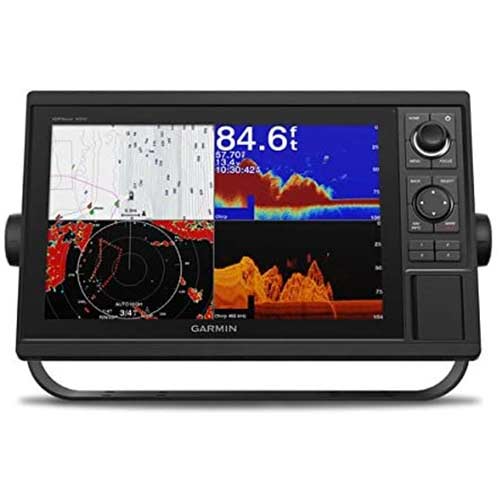
Garmin GPSMAP 1242xsv 12-Inch Marine GPS
$2,199.99
Description
Garmin GPSMAP 1242xsv 12-Inch Marine GPS
- 12-Inch color display with keypad interface and multifunction control knob
- Preloaded U.S. LakeVü HD maps and Blue-Chart g2 charts
- High-sensitivity internal 10-Hz GPS and GLONASS receiver
- Built-in single-channel CHIRP sonar, CHIRP ClearVü and CHIRP SideVü scanning sonar and Panoptix support (transducers sold separately)
The Garmin GPSMAP 1242xsv 12-Inch Marine GPS 12-inch Chartplotter/Sonar Combo Is “All-in-1” Solution
- 12” color display with keypad interface and multifunction control knob
- Built-in support for Garmin CHIRP sonar and CHIRP ClearVü and CHIRP SideVü scanning sonars (transducers sold separately)
- Preloaded BlueChart® g3 charts and LakeVü g3 maps
- High-sensitivity internal 10 Hz GPS and GLONASS receiver
- Fully network capable for Garmin Marine Network and NMEA 2000® connectivity plus NMEA 0183 support
Experience an advanced all-in-one solution with the Garmin GPSMAP 1242xsv 12-Inch Marine GPS keyed combo. It has built-in support for Garmin CHIRP sonar and CHIRP ClearVü and CHIRP SideVü sonars. It also has built-in support for Panoptix™ all-seeing sonar and premium Garmin sonar modules (transducers sold separately). Features include a large, bright screen coupled with a quick and easy-to-use keypad interface with user-programmable keys and a multifunction control knob.
The Garmin GPSMAP 1242xsv Offers Complete Network Sharing
Garmin Marine Network support allows sharing of sonar, maps, user data, dome or open-array radar, IP cameras, and Panoptix sonar among multiple units. Plus, there’s NMEA 2000 network connectivity and NMEA 0183 support for autopilots, digital switching, weather, media, VHF, AIS, and other sensors.
Preloaded with Exceptional Garmin Cartography
LakeVü g3 inland maps and BlueChart® g3 coastal charts provide industry-leading coverage, clarity, and detail with integrated Garmin and Navionics® data and Auto Guidance1 technology. LakeVü g3 and BlueChart g3 include Auto Guidance1, which uses your desired depth and overhead clearance to calculate routes and provide a suggested path to follow. LakeVü g3 provides coverage on more than 17,000 lakes with up to 1’ contours. BlueChart g3 also includes NOAA raster cartography, available as a free downloadable feature via the ActiveCaptain® app.