Cast off confidently with the Garmin GPSMAP 86S Floating Handheld GPS. Whether you’re out for a day of fishing, sailing, or cruising, you’ll gain peace of mind that comes from having a backup navigator. This premium handheld floats and has a sunlight-readable 3” Color display. Plus, wireless connectivity makes it a virtual extension of your onboard marine system, giving you added awareness and convenience.
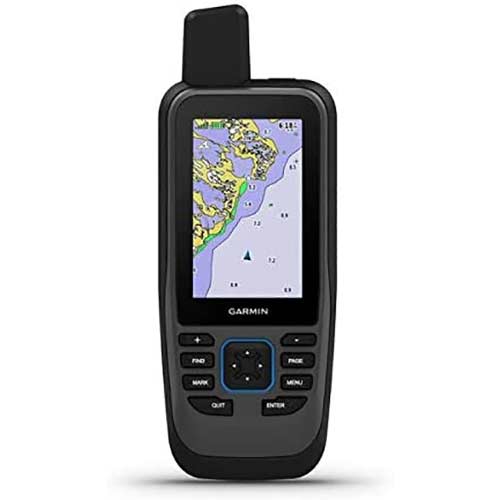
Garmin GPSMAP 86S Floating Handheld GPS
$299.99
Description
Garmin GPSMAP 86S Floating Handheld GPS
Cast off confidently with the GPSMAP 86s handheld. Whether you’re out for a day of fishing, sailing, or cruising, you’ll gain peace of mind that comes from having a backup navigator. This premium handheld floats and has a sunlight-readable 3” color display. Plus, wireless connectivity makes it a virtual extension of your onboard marine system, giving you added awareness and convenience.
- Water-resistant, Floating Handheld GPS, sunlight-visible 3” display, and button operation provide ease of use on the water
- Stream boat data from compatible chartplotters and instruments to consolidate your marine system information
- Functions as a remote control for convenient operation of your Garmin autopilot and Fusion Marine products; to activate, download free apps from our Connect IQ store
- Supports optional blue chart G3 charts
- Adjustable GPS filter smooth speed and heading indications over swells
- Pair with your compatible smartphone to receive smart notifications
- Internal, rechargeable lithium battery provides up to 50 hours of battery life in 10-minute tracking mode
Connect with Your Boat
Sync GPSMAP 86s with compatible Garmin chartplotters and instruments, and you’ll see real-time boat data displayed right on your handheld. Plus, it can serve as a remote control for convenient operation of your Garmin autopilot and select FUSION marine products. And when you’re underway, an adjustable GPS filter smooths speed and heading indications as you pass over swells for more accurate tracking.
Optional BlueChart g3 Charts
GPSMAP 86s comes preloaded with a worldwide basemap. It also allows you to add BlueChart g3 coastal charts, giving you industry-leading coverage, clarity, and detail with integrated Garmin and Navionics® data. Detailed contours allow you to see 1’ contours that provide a more accurate depiction of bottom structure for improved fishing charts and enhanced detail in swamps, canals, and port plans.