The Garmin GPS MAP176C 3.8-Inch Waterproof Marine GPS and Chartplotter is a 12 parallel channel, WAAS-capable GPS receiver with an extra-large, 16-color display that makes keeping your eye on the map easy. The display measures 3.75 inches diagonal and delivers a crisp picture thanks to a pixel count of 320 x 240. On the inside, the GPSMAP 176C comes equipped with a built-in worldwide basemap and tide data for the United States.
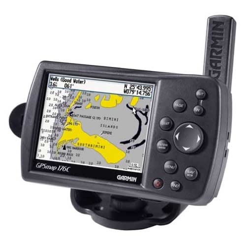
Garmin GPS MAP176C 3.8-Inch Waterproof Marine GPS and Chartplotter
$379.95
Description
Garmin GPS MAP176C 3.8-Inch Waterproof Marine GPS and Chartplotter
The Garmin GPS MAP176C is 3.8-Inch Waterproof Marine GPS and Chartplotter is a powerful 12-parallel channel GPS receiver with Wide Area Augmentation System (WASS) capabilities. WAAS is an enhancement to GPS that receives signals from additional satellites to improve mapping accuracy to within three meters. Another charting feature is Garmin’s exclusive BlueChart marine cartography, which provides offshore map details like contours, inter-tidal zones, spot soundings, wrecks, port plans, and restricted areas.
With a backlit grayscale display measuring 3.8 inches diagonally and a pixel resolution of 320 x 240, you definitely won’t have to strain your eyes while trying to read directions.
The Garmin MAP176C GPS is also equipped with a built-in basemap of the Americas with cities, highways, interstates, exit information, rivers, lakes, and U.S. tide data. Navigation functions are provided, like 3,000 waypoints, 50 reversible routes, a trip computer, alarm, and celestial tables.
You can easily download maps from your computer for your specific GPS needs: the GPSMAP 176 is compatible with most MapSource products such as Garmin BlueChart marine cartography, MetroGuide, and Fishing HotSpots.
The GPSMAP 176 includes a PC cable, power/data cable, marine mount, owner’s manual, and quick reference card.
Garmin GPS MAP176C 3.8-Inch Waterproof Marine GPS and Chartplotter Key Features
- 12-parallel channel receiver
- Wide Area Augmentation System (WAAS) enabled
- Features Garmin’s exclusive BlueChart marine cartography
- 3.8-inch backlit 16-color display
- Resolution of 320 x 240; accepts downloadable information from Garmin’s MapSource line